Natural Heritage Division
Jung, Seungho
In 2000 in Pohang, Gyeongsangbuk-do Province, a columnar joint with a polygonal cross-section was found along the slope of a mountain that used to be a quarry. The geological structure was formed when basaltic lava erupted to the surface and cooled down during the Miocene Epoch of the Cenozoic Era (roughly 15 million years ago). The 20-meter-high and 100-meter-wide structure is surrounded like a folding screen. It was designated as a Natural Monument in recognition of its academic value as it is located inland, away from the coast, and the joints are developed vertically and radially. In general, when high-temperature magma or lava comes into contact with the surrounding air (or the ground) or water and cools, a contraction occurs and columnar joints are formed. At this time, the contact surface (cooling surface) shows the most stable and efficient cross-sectional shape (mostly quadrangle to septangle) as the volume decreases and columnar joints are developed by extending vertically to the contact surface, as if polygonal stone pillars were clustered together to form a bundle. After its value was recognized, Jeju Jungmun and Daepo Coastal Columnar Joints (2005), Mudeungsan Columnar Joints (2005), and Gyeongju Yangnam Columnar Joints (2012) were also designated as natural monument1) as well, and columnar joints with various formation periods, constituent rocks, and distribution patterns have been nationally preserved and managed.
Monitoring After Multiple Earthquakes:
Columnar Joint in Daljeon-ri, Pohang
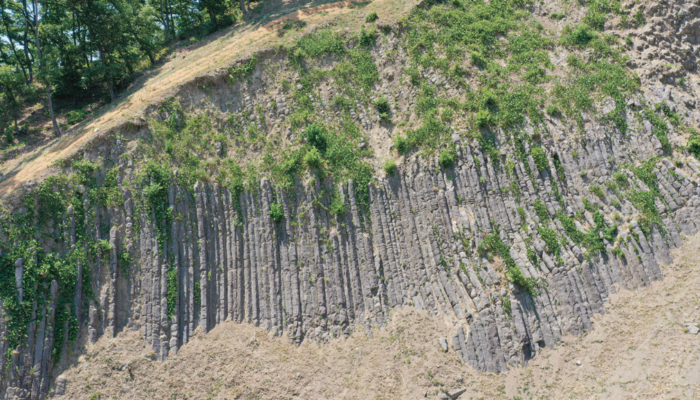
The Pohang Daljeon-ri Columnar Joint consists of a number of naturally formed vertical and horizontal joints. It is weathered and eroded continuously due to unstable steep slopes, upper vegetation cover and soiling, while a series of earthquakes hit Gyeongju (magnitude 5.8) and Pohang (magnitude 5.4) in 2016 and 2017 raised awareness of damage to natural heritage and large-scale disasters. The Natural Heritage Division of the NRICH designated the Pohang Daljeon-ri Columnar Joint as a priority management object due to its vulnerability to earthquakes and monitoring its rockfall monthly since 2018. The monthly monitoring showed that rockfall from the columnar joints is mainly caused by various causes such as seasonal factors (temperature change and growth of plants), wind, rainfall and mineralogical characteristics of the rock. It mostly happens during the thawing and the rainy season (directly influenced by monsoons or typhoons). Although we do not yet have data to relate rockfalls with earthquakes, we have also proposed the local governments the need to prepare mid- to long-term management measures in preparation for this.
Natural Damage Factors and Indiscriminate Industrial Development: Columnar Joint in Yangnam, Gyeongju
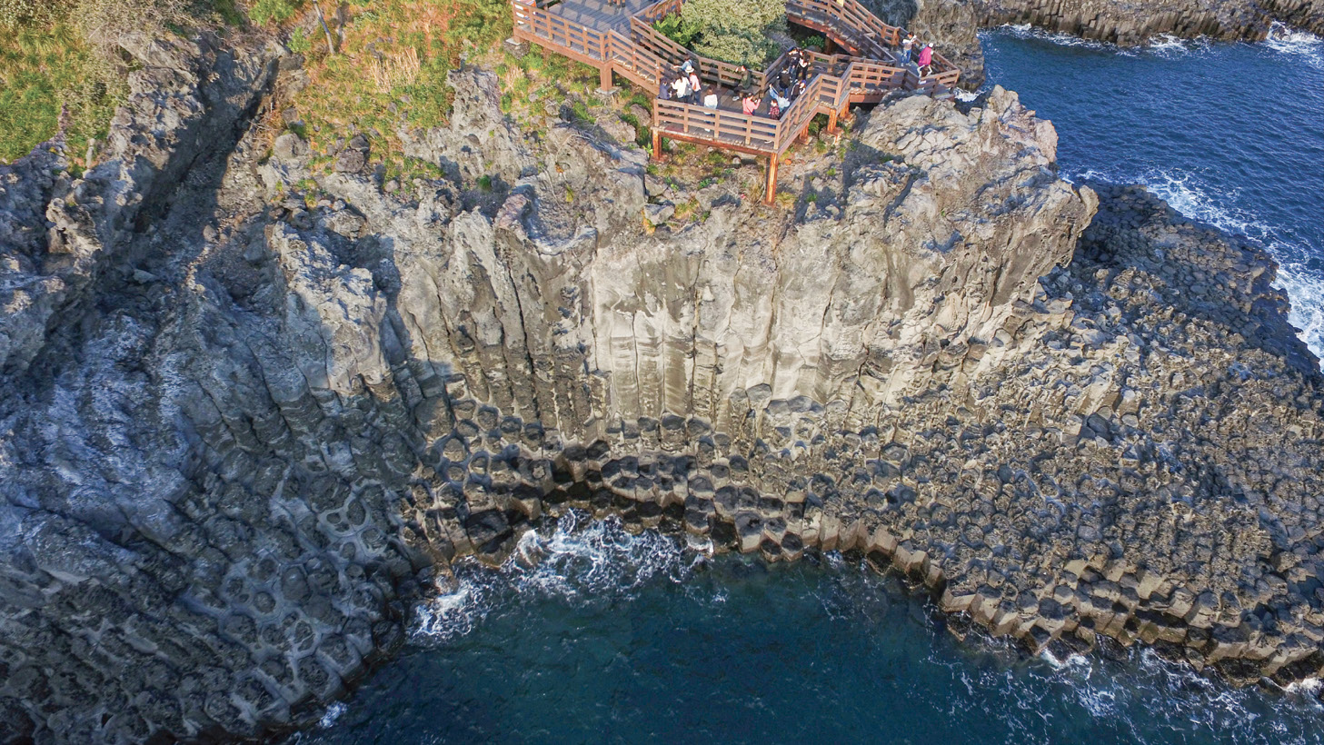
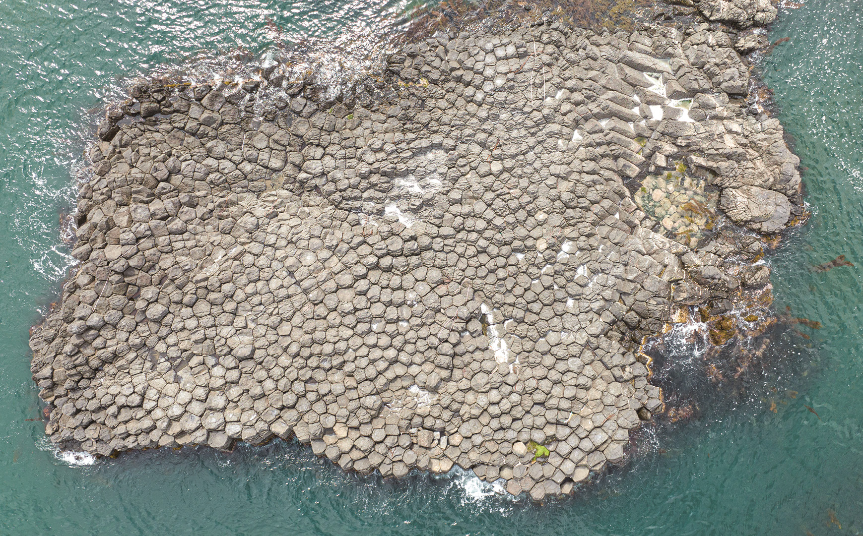
The columnar joints cluster in Yangnam, Gyeongju, located along the shore, was created during the Miocene Epoch of the Cenozoic Era (about 20 million years ago) by active volcanic activity in the southeastern part of the Korean Peninsula in relation to the opening of the East Sea2). The distribution pattern, size and shape of columnar joints are very diverse. The diameter of the cross-section is between 20 and 100 centimeters, while the diameter between 30 and 50 centimeters predominates. The shape of the cross-section is primarily pentagonal or hexagonal.
The columnar joints are developed in various ways, including vertically, inclined, horizontal or fan-shaped like a circle. Along the coastal promenade Padosori-gil (a 1.7 kilometers route between Eupcheon Port and Haseo Port), you can observe columnar joints that overlap in various shapes or develop in different directions. There always are possibilities of natural damage due to the composition of rocks, joint development characteristics, waves and tides. Moreover, many restaurants and accommodations are concentrated along the boundaries of the designated protected areas, so we requested the managing entity of Gyeongju City to constantly improve the environment and observe the changes over worries regarding possible indiscriminate industrial development that may cause harm to the natural environment.
Efforts to Preserve and Manage Natural Heritage:
First Step in 3D Digital Documentation
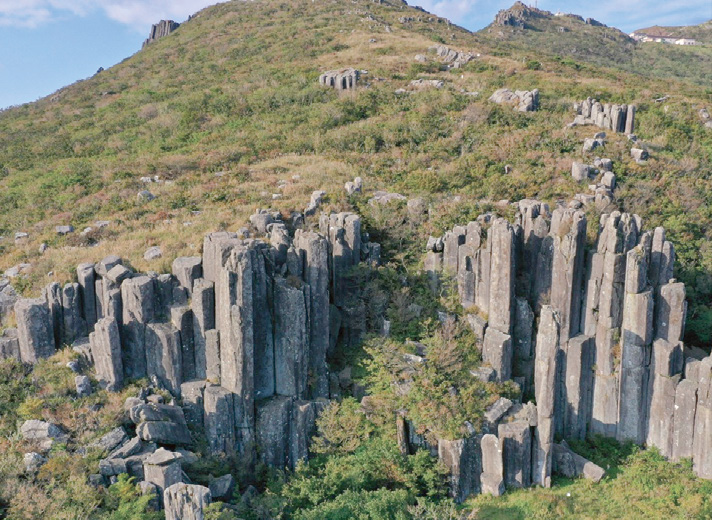
In October 2020, inquiries regarding rockfall risks were received in the Ipseokdae Rock section of the Mudeungsan Columnar Joints. The columnar joint in Mudeungsan Mountain was formed as a result of volcanic activities during the Cretaceous period of the Mesozoic Era (approximately 85 million years ago). Composed of Mudeungsan tuff, the columnar joint is distributed at an altitude of 950 to 1,050 meters above sea level, differentiating from other columnar joints. In particular, the Ipseokdae Rock and the Seoseokdae Rock consist of dozens or hundreds of independent stone pillars with pentagonal or hexagonal cross-section shapes that developed vertically or spread like a folding screen. Each stone column has a circumference of 6 to 7 meters and a height of 10 to 20 meters, and the Mudeungsan Columnar Joints are one of the largest columnar joints in South Korea. We analyzed the changes in the columnar joints according to previous periodic survey reports and related data. We found that the reported cracks are not a recent deformation to the columnar joints. Still, in a regular survey in 2015, we observed no visible changes in the facade, such as collapse, fall or reversal. Nevertheless, due to the inherent nature of the columnar joint, there is a possibility of natural weathering or damage due to the natural development of the vertical and horizontal joints. Hence, additional efforts should be made to prevent rockfalls that could threaten the safety of climbers and visitors.
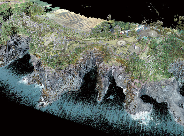
Natural heritage is widely distributed and often exposed outdoors, resulting in difficulties in managing and preserving it from erosion and weathering, rapid environmental change (abnormal climate) and occasional artificial damage. The Natural Heritage Division is attempting to document natural heritage in three dimensions with the Digital Heritage Team of the Cultural Heritage Administration (CHA) to find ways to find a sustainable management and utilization plan. In other words, we aim to construct accurate basic data of the site using digital technology and applying various methods suitable for each type, overcoming internal and external research environment’s limitations and preparing additional measures.
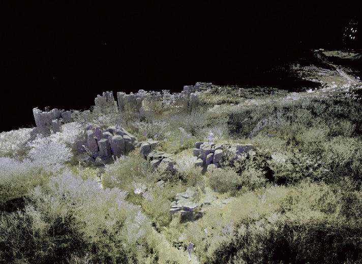
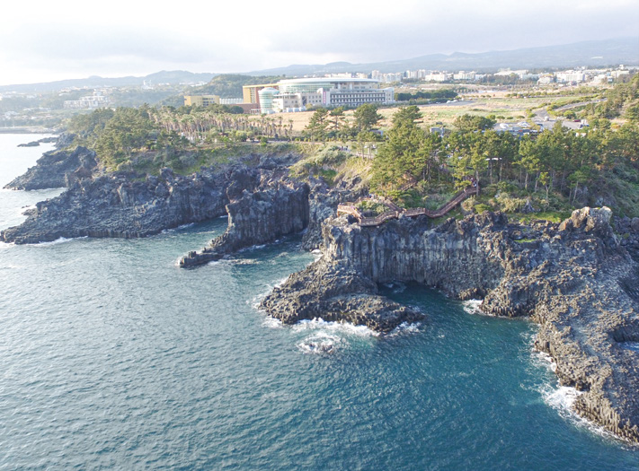
The Jeju Jungmun and Daepo Coastal Columnar Joints, exposed in various forms over a coast of about 2.7 kilometers, were formed in the Pleistocene Epoch in the Cenozoic Era (about 250,000 years ago). It is an important geological resource to study and observe the geological phenomenon when basalt lava hardens and the development of coastal topography due to marine erosion. Most columnar joints are sea cliffs and are constantly influenced by waves and typhoons, so periodic monitoring is necessary to identify changes to the columnar joints. Considering the weather conditions such as wind, seawater and waves, we attempted to document the shape of the entire columnar joints, the development of the joints, the status of rockfall, and the data on overlapping and curved slopes using scanning equipment accessible to the site to acquire data continuously from both above and below the sea level. Data collected by drones, broadband scanners and photography are compared with the result of the Mudeungsan Columnar Joints, located in inland/mountainous terrain to find data processing and application measures suitable for the situation.
Through these attempts, we prepare a standard plan for building 3D data for each natural heritage, establish a reasonable conservation plan with preventive management system and make sustainable use of natural heritage through regular surveys, constant monitoring and field investigation.
1) Four of the 88 geological natural monuments designated in Korea are columnar joints.
2) East Sea opening: The plate tectonics that opened the East Sea as the Japanese Archipelago separated from the continent from the Oligocene Epoch to the Miocene Epoch of the Cenozoic Era.
3) Kim et al., 2021, A Study on Evaluation of Slope Stability and Range of Rockfall Hazard of Daljeon-ri Columnar Joint in Pohang, Korea. Journal of Conservation Science, 37(5), 505-515 (in Korean).