Major Achievements and Significance of the Join Research on the Ancient Tombs in Zhetysu, Kazakhstan (2015-2019)
KIM Hyunyong
Korea and Kazakhstan are approximately 5,000 km apart. Nevertheless, the ancient cultural heritage of these two distant countries share many similar characteristics. An ornamented golden daggar from an ancient tomb of Silla, which resembles one discovered in ancient remains in Kazakhstan, suggests that artifacts manufactured in the same location were relocated to different parts of the globe. Still, the distributor is unknown, and moreover the heydays of golden artifacts differ in these two regions. Moving forward, the National Research Institute of Cultural Heritage (NRICH) will strive to piece together the puzzle of this ancient mystery.Eurasia, which connects Europe and Asia, is the largest continental area on the planet, accounting for some 40 percent of the Earth’s land surface. Consequently, the region has been the venue of turbulent vicissitudes for its diverse ethnic groups and cultures linked together through mutual exchanges.
The Korean Peninsula is situated in the easternmost part of Eurasia. Such geopolitical circumstances meant that, in the past, a wide range of cultures arrived in Korea after series of exchanges and transformations. In this regard, the Korean Peninsula once was the final destination for Eurasian cultures and the departure point for the Korean Wave the present-day global sensation.
Against this backdrop, National Research Institute of Cultural Heritage(NRICH) of Korea has been tracing Eurasia’s ancient cultural network to explore diverse aspects of the formation of ancient culture on the Korean Peninsula and its exchanges with other regions through various interdisciplinary angles. In the field of archaeology, the NRICH has been conducting joint research projects with national research institutions in Kazakhstan, Mongolia, and other countries in Central Asia, regarding ancient tombs that can help paint a clear picture of ancient cultures. This paper will introduce the achievements and significance of our joint research with Kazakhstan over the course of five years.
In Silla, one of the ancient kingdoms on the Korean Peninsula, gigantic tumuli began to appear in the late 4th century. Among these tombs, the largest ones measure 80m in diameter and over 20 m in height. The person buried in such a tomb wore an elaborate outfit and accessories decorated with gold, and was placed in a wooden chamber, together with a wide variety of burial goods. The wooden chamber was covered with a great deal of stone and then with earthen mound to prevent robbery and also to symbolize the authority and power of the deceased. This type of tomb is referred to as a wooden chamber tomb covered by stone and earthen mound.
Since wooden chamber tombs covered by stone and earthen mound have been differentiated from their predecessors in multiple aspects (e.g. structure, form, and in the use of golden objects as burial goods), identifying the causes and historical contexts of their appearance has beenthe issue of great interest among researchers. A kurganhas been pointed out as one background detail, a type of tomb used by nomads that is extensively distributed in Central Asia.
Kurgans⑴ are found all around Kazakhstan, a representative Central Asian country. They are important cultural resources belonging to the Early Nomadic Period in the 8th to 3rd century BCE. In 2014, the NRICH signed an academic exchange agreement with the Institute of Archeology Margulana in Kazakhstan. Subsequently, the isntitute signed a new academic exchange agreement with the Cultural Heritage Institute of the National Museum of the Republic of Kazakhstan for continued research.
⑴ Kurgan A kurgan generally refers to an ancient tomb with an earthen mound. Deriving from a Turkic word that means an “earthen mound” or “hill,” the term kurgan already appears in archaeological studies from prior to the 20th century, suggesting its prolonged use. Although what a kurgan signified in a society may have varied, depending on the culture and period to which it belonged, this ancient tomb , which first appeared during the Bronze Age, reflects the concentration of labor and social wealth that accompanied the concurrent shifts in social structure. Furthermore, large kurgans that began to appear in Siberia during the Scythian Period could not have been constructed without the establishment of a well-organized social structure. In particular, large kurgans found in southern Siberia, representative of the Pazyryk culture, have been the subject of great interest in terms of their relationship with Silla’s wooden chamber tombs covered by stone and earthen mound; their influence in the enlargement of the earthen mounds of these Silla tombs: and their similarities with their Silla counterparts in terms of internal structure(National Research Institute of Cultural Heritage, Dictionary of Korean Archaeology, Seoul: National Research Institute of Cultural Heritage, 2001).
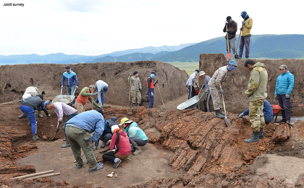
The joint research has aimed to secure basic resources necessary for reconstructing Eurasia’s ancient cultural network and to conduct a comparative study with other countries and this has been carried out through archaeological surveys on kurgans, tumuli built by nomadic peoples, the main agents of the Silk Road. The field research mainly consisted of archaeological excavations and surveys of the current distribution of kurgans.
From 2015 to 2018, archaeological excavations were conducted on the Katartobe ancient tombs site, located to the southeast of the Zhetysu region, an important hub along the Silk Road.
The excavations identified at least 50 burial and ritual structures from varying periods of history. At the site, rectangular- and circular-planned kurgans are arranged in four main rows in the north–south direction, with each kurgan measuring 10–60 m in diameter and 1–4 m in height.
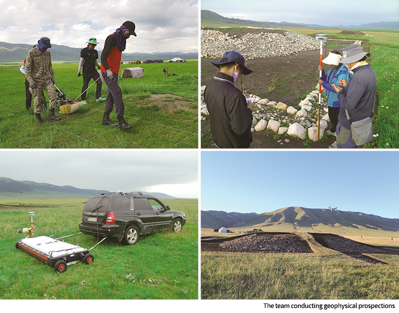
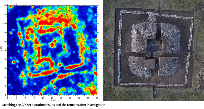
Prior to the excavations, the research team first conducted geophysical propections to obtain as much preliminary information as possible. Geophysical prospection is analogous to a doctor taking an X-ray or CT scan of a patient before performing surgery.
Geophysical prospection is a nondestructive archaeological research method used to create distribution maps of underground remains. The mechanism works by sending out electromagnetic waves toward an underground location and analyzing the difference in the strength of the waves that bounce back to the detector. This analysis can reveal the underground structure and the distribution of buried objects. However, the outcomes of geophysical prospection do not provide direct information on underground artifacts or remains. For example, such outcomes do not tell us, “A wooden coffin or golden object is buried underground.” That is, the method cannot determine the characteristics of specific artifacts or remains buried underground. Still, merely creating a distribution map of certain structures or objects that are different from regular underground soil can itself provide highly desirable information.
Based on the scientific archaeological technologies accumulated over the years, the NRICH conducted ground penetrating radar(GPR), GPS and drone surveys on the Katartobe ancient tombs site. These surveys were carried out four times from 2015 to 2018. In Katartobe Tomb No 2-1, the GPR surveys identified traces of a rectangular stone structure stacked between the earthen mound and the tomb’s boundary as well as GPR responses that suggested the existence of a burial chamber at the center of the earthen mound. A subsequent comparison with actual excavation outcomes has confirmed that geophysical prospection is an outstanding method that can identify the existence and shape of underground remains in a nondestructive way.
Archaeological excavations, which were conducted on a total of nine kurgans, identified that tombs from the Saka Period (5th to 3rd century BCE) are structured in such a way that several burial chambers are placed under one earthen mound. Furthermore, an examination of the stratigraphic profiles of these chambers, which had been conducted to better understand the burial process, revealed that the bodies were not buried sequentially but all at once, suggesting the possibility of the human sacrifices or mass death by war or disease.
A similar case can be found in the comitatus system practiced during the Roman Republic. A comitatus was the armed retinue of a military commander. Comitatus soldiers and their leader formed a kind of vassal-lord relationship, where vassals swore fealty to their lord in exchange for material privileges. Some researchers believe that this system originated, prior to the Roman Republic, from the Scythians, an ancient nomadic people. Unfortunately, our research failed to identify the cause of death shared by those buried in the tomb due to the poor condition of the human skeletal remains. However, we hope that our future research on the kurgans will reveal the mystery of their deaths and societal relationships.
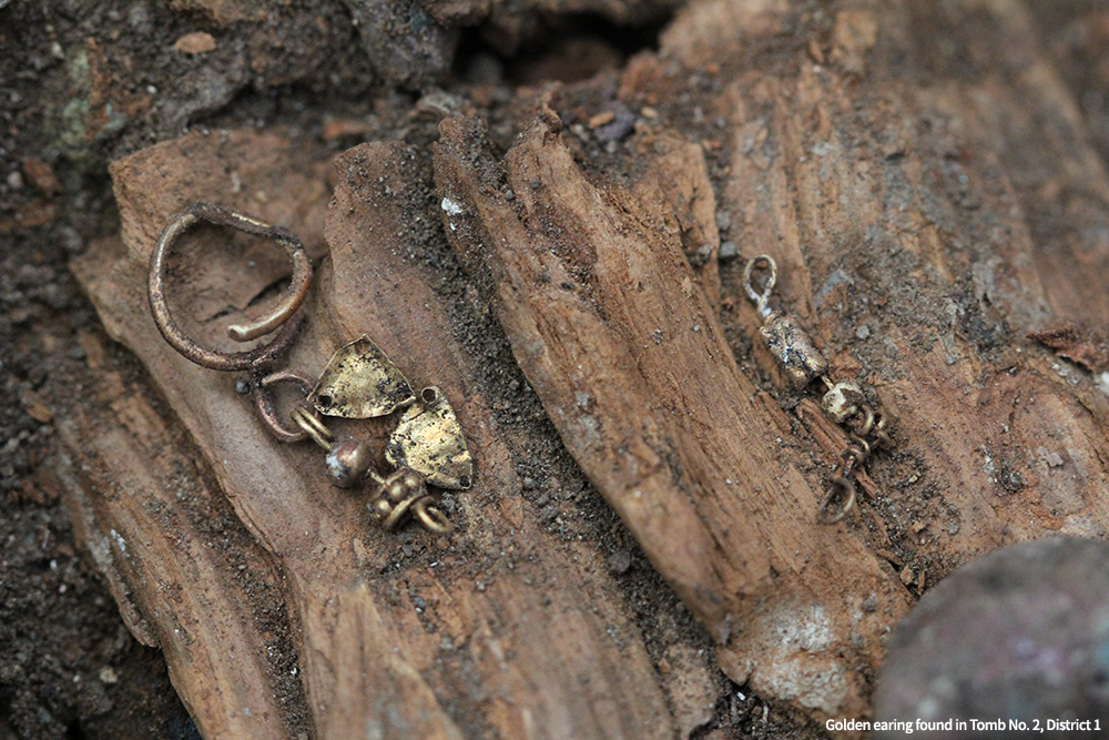
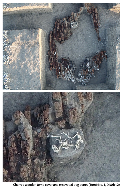
The joint research team also shed new light on the earthenwork of the kurgans, which, during the extension work of their earthen mounds, utilized alternating layers of different soil to prevent collapse. In addition, unearthed grave goods, animal bones, and the burnt cover of a wooden chamber suggest that burials were accompanied by rituals.
In addition to archaeological investigations, diverse interdisciplinary research was conducted on kurgans. To begin with, in the domain of natural science, to estimate the absolute dates of the site, radiocarbon dates of charcoal samples collected from the tombs were determined. To enhance credibility, the samples collected from the same location were commissioned to two different analysis labs. The determined radiocarbon dates of the samples indicate that the tombs were built between the 5th to 2nd century BCE, the period when the ancient Saka culture flourished.
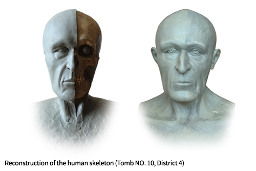
At the same time, human skeletal remains recovered from the kurgans were analyzed from a physical anthropological perspective. The study found that the average height of the men buried in the kurgans were 170–180 cm, and the average height of the women more than 170 cm. These results indicate that their physique was similar to that of a modern person. Furthermore, a flesh reconstruction of unearthed skulls revealed that the buried were Caucasoid.
A stable isotope analysis was also performed on collagen samples extracted from human skeletal remains to identify the nutritional sources of the buried and to reconstruct their dietary patterns. The analysis determined that the diet of the ancient Saka people consisted mainly of meat and dairy products accompanied by a small amount of grain such as wheat, oat, millet, and maize.
As for unearthed animal remains, researchers thoroughly examined physical traces, including traces of weathering, plant roots, tools, heating, and gnawing by other animals. At the same time, based on the recovery location and the physical integrity of the remains, they speculated on the cause of these animals’ deaths and how they were used. As a result, it was revealed that domesticated horses, dogs, sheep, and cattle were brought together as a collective sacrifice during a funeral, among which sheep and horses in particular were served as funeral food. Notably, evidence indicates that dogs used as sacrificial offerings all suffered from anemia due to an unknown disease.
The earthenware recovered from the kurgans was also analyzed using multiple scientific techniques including the ingredients of the clay used, production techniques, and firing methods. The analysis confirmed that nomads at the time used clay from different locations to make earthenware; and that they added tempers including burnt bone, wet compost, compound organic matter, and other ingredients to the clay. In addition, it was revealed that to shape the earthenware, a mold was used to put together clay coils; that sheepskin or sheep leather was used to smooth the clay surface; and that earthenware was fired at a temperature of no more than 700℃, from an openair location and not from within a kiln.
To promote public access to domestic and overseas archaeological surveys conducted by the institute, the NRICH has been producing immersive media content for the general public, using drone technology. In particular, the institute provides a platform that offers 360-degree video VR tours of hard-to-reach overseas archaeological excavation sites to the Korean public (http://vrnrich.kr).
As for the current distribution of kurgans, field surveys (2018–2019) were conducted on kurgans in Zhetysu, Almaty Province and Altai, East Kazakhstan Province. The wondrous and wild natural environment of the two regions seemed long deserted, but every place the research team visited was home to traces of ancient nomads. Kurgans were built in three major periods: namely, the Early Saka Period (8th to 6th century BCE), the Saka–Wusun Period (5th to 2nd century BCE), and the Hun–Sarmatia Period (2nd century BCE to 5th century CE). The research team obtained diverse resources on 134 ancient sites, including GPS records, drone aerial photos, and information on the locations and arrangements of the kurgans. These are expected to serve as crucial resources for the future study of the ancient Eurasian cultural network.
Despite the long distance between Korea and Kazakhstan, ancient cultural heritage of the two countries share many similarities. For instance, in 1973, an exotic golden dagger was unearthed from Gyerim-ro Tomb No. 14, a tomb from Silla, an ancient kingdom on the Korean Peninsula. Notably, a very similar ornamental dagger was also found in the Borovoye site, Kazakhstan, a site some 5,000 km away. This suggests not that the craftsmanship was diffused into or emulated by Silla, but that objects produced from the same location were transported to different locations. However, the identity of the conveyor can only be surmised, without any definite evidence.
The structure of the two country’s ancient tombs (kurgans vs. wooden chamber tombs covered by stone and earthen mound) are also similar. In addition, the design motifs and craftsmanship used in the golden artifacts of the two regions share many similar characteristics, including upright ornaments in the shape of tree branches or antlers found in golden crowns, filigree techniques utilizing tiny golden beads, and gemstone setting techniques.
However, despite such similarities, the temporal disparity between the two cultures remains an unsolved mystery. In Kazakhstan, the making of tumuli and golden artifacts flourished after the 8th century BCE, during the Saka Period. However, in Silla, the heyday began after the 4th century CE. To explain this time gap, a wide variety of research on extensive regions must be conducted from a diachronic perspective. Ancient human cultures may not have changed or developed as rapidly as they do today. We can only assume that they must have evolved in a network of relationships with other regions around the globe. Moving forward, the NRICH will continue to put together this mysterious puzzle, one piece at a time.